AND NORTH AMERICA
(arranged by date of publication)
Also see other maps of the U.S. and North America in the Atlases section. Some state maps are also in the Maps of the South section.
Click on the small image to see a larger image of a map,
then use the Back button on your Browser to return to this page.
To purchase a map, just click on the Add to Cart button.
A list of the maps in this section with links to the maps:
| CAR-MAP-072 - Ameriae sive
qcaetae..., Belgium |
CAR-MAP-445
- North America, Sanson, 1650 |
| CAR-MAP-424
- Mississippi River, Franquelin, 1682 |
CAR-MAP-220
- Louisana (all of the U.S.), Franquelin, 1684 |
| CAR-MAP-444
- Northeast America, Visscher, 1685 |
CAR-MAP-429
- North America, Fraquelin, 1688 |
| CAR-MAP-449
- Dominion of Great Britian in North America, Moll, 1715 |
CAR-MAP-316
- Carte de la Louisina (U.S.) , L'Isle, 1718 |
| CAR-MAP-130
- Carta Geografica dell' America, L'Isle, 1750 |
CAR-MAP-104
- Virginia, Fry & Jefferson, 1751 |
| CAR-MAP-270
- British American Plantations, Bowen, 1751 |
CAR-MAP-380
- British & French dominions in North America,
Mitchell, 1755 |
| CAR-MAP-114
- Middle British Colonies in America, Evans, 1751 |
CAR-MAP-194
- North America, Jefferys, 1771 |
| CAR-MAP-447
- North America, Bell, 1771 |
CAR-MAP-462
- Rivers of Tombecbe, Alabama, etc., Taitt, 1771? |
| CAR-MAP-195
- British Colonies in North America, Jefferys, 1771 |
CAR-MAP-103
- North America, British, Spanish & French Dominions,
Bowen |
| CAR-MAP-190
- Boston & Surrounding Area, 1775 |
CAR-MAP-191
- Boston & Surrounding Area, De Costa, 1775 |
| CAR-MAP-192
- Plan of Boston & Environs, Page, 1776 |
CAR-MAP-442
- North America, Carver, 1778 |
| CAR-MAP-118
- U.S. - Treaty of Peace 1783, Cary, 1783 |
CAR-MAP-450
- Cherokee Lands ceeded to NC in 1783, 1846 |
| CAR-MAP-271
- U.S. & adjoining provinces, Conder & Wilkinson,
1791 |
CAR-MAP-268
- 1776 - Original 13 colonies, Mitchell, 1881 |
| CAR-MAP-064
- U.S. - treaty of 1784, Faden, 1785 |
CAR-MAP-269
- Central Area of U.S. (in French), Boone & Andre,
1788 |
| CAR-MAP-470
- U.S. post roads & distances, Bradley, 1796 |
CAR-MAP-175
- New discovers in interior of North America, Arrowsmith,
1802 |
| CAR-MAP-277
- Central area of U.S. (in French), Poirson, 1803 |
CAR-MAP-443
- Area around New Orleans (in French), Lafon, 1806 |
| CAR-MAP-507
- SE U.S., Carey, 1806 |
CAR-MAP-458 - Vermont, Carey, 1814 |
| CAR-MAP-461 - Mississippi & Alabama territory, Carey, 1814 | CAR-MAP-099 - U.S., Wallis, 1911 |
| CAR-MAP-374 - War of 1812, Conrad & Lewis, 1812 | CAR-MAP-157 - Lewis & Clark's Track, Lewis, 1814 |
| CAR-MAP-276 - Southern U.S., Melish, 1816 | CAR-MAP-368 - U.S., Melish & Tanner, 1816 |
| CAR-MAP-183 - Santa Fe Trail, Brown, 1825 | CAR-MAP-265 - North America, Vance, 1826 |
| CAR-MAP-428 - Pennsylvania, Finley, 1829 | CAR-MAP-057 - U.S., Tanner, 1830 |
| CAR-MAP-433 - MA, CT & RI, Young, 1831 | CAR-MAP-062 - U.S., Tanner, 1835 |
| CAR-MAP-379 - Pennsylvania & New Jersey, Bradford, 1835 | CAR-MAP-050 - Carte des Etas-unis DAmerique... (in French), Bernard, 1836 |
| CAR-MAP-266 - Indian Tribes of North America 1600, Gallatin, 1836 | CAR-MAP-061 - U.S., Mitchell, 1836 (a poor quality image) |
| CAR-MAP-436 - MD, DE & part of PA & VA, Lucas, 1836 | CAR-MAP-355 - Texas, Oregon & Californis, Mitchell, 1846 |
| CAR-MAP-127 - U.S., British Provinces, Mexico, etc., Atwood, 1849 | CAR-MAP-304 - Phelps National Map of the U.S., 1852, Atwood |
| CAR-MAP-060 - Mitchell's U.S. Traveler's Guide, Cowperwaith, 1853 | CAR-MAP-334 - Western States, RR & Township map, Colton, 1853 |
| CAR-MAP-335 - MS, RI & CT, Colton, 1853 | CAR-MAP-331 - Ohio, Colton, 1854 |
| CAR-MAP-421 - New England, Ensign, etc., 1856 | CAR-MAP-323 - Delaware & Maryland, Colton, 1856 |
| CAR-MAP-326 - Massachusetts & Rhode Island, Colton, 1856 | CAR-MAP-343 - Illinois, Iowa & Missouri, Johnson, 1857 |
| CAR-MAP-490 - Western U.S., Warren, 1858 | CAR-MAP-371 - U.S., Phelps & Watson, 1859 |
| CAR-MAP-432 - North Carolina & Virginia, Mitchell, 1860 | CAR-MAP-336 - New England, Colton, 1861 |
| CAR-MAP-176 - Naval & Military map of U.S., Smith, 1862 | CAR-MAP-370 - U.S., Colton, 1862 |
| CAR-MAP-136 - North America, Johnson, 1863 | CAR-MAP-225 - Washington, D.C., Johnson, 1865 |
| CAR-MAP-570 -
Clarion Co., PA, Pomeroy, 1865 |
CAR-MAP-434 - Arizona & New Mexico, Mitchell, 1867 |
| CAR-MAP-440 - U.S., Mitchell, 1867 | CAR-MAP-344 - Minnesota & Wisconsin, Lloyd, 1871 |
| CAR-MAP-464 - Los Angeles as of 1871, Gores, 1929 | CAR-MAP-166 - U.S., Gray, 1879 |
| CAR-MAP-193 - Massachusetts, Williams, 1879 | CAR-MAP-441 - Palisades of the Potomac, Brewer, 1890 |
| CAR-MAP-439 - Solano County, California, 1890 | CAR-MAP-293 - California for Cyclers, Blum, 1895 |
| CAR-MAP-110 - Maps from the 1895 Rand McNally Atlas - see Atlas section | CAR-MAP-315 - U.S., Century Atlas, 1902 |
| CAR-MAP-425 - Oklahoma, Century Atlas, 1902 | CAR-MAP-448 - Territory of New Mexico, U.S. Dept. of Interior, 1903 |
| CAR-MAP-294 - Clarion, PA topographical map, USGS, 1907 | CAR-MAP-087 - U.S. - explorers routes, Bond, 1907 |
Americae sive qcaetae orbis
partis... A very ornate Belgium map of
the Americas. Created from a print at the Library
of Congress Archives; 33" x 34" North America;
Sanson; 1650; from a copy at the Library of
Congress Archives; 17" x 22" Franquelin's Map of the
Mississippi River; 1682; Created from
a print at the Library of Congress Archives; 16"x
17" Northeast America;
Visscher; 1685; from a copy at the Library of
Congress Archives; 17" x 22" Dominion of Great Britain in
North America; Moll; 1715; from a copy
at the Library of Congress Archives; 40" h x 24"
w. Carte de la Louisiana...
a map of the southern states; L'Isle; 1718.
Created from a print at the Library of Congress
Archives; 19" x 25" Map of the British American
plantations; Emanuel & Thomas
Bowen; 1754; from a copy at the Library of
Congress Archives; 20" x 16" A General map of the Middle
British Colonies in America; Lewis
Evans; 1771; from a copy at the Library of
Congress Archives; 19" x 26" North America;
Jefferys; 1771; from a copy at the Library of
Congress Archives; 31" h x 23" w. North America; Peter
Bell; 1771; from a copy at the Library of Congress
Archives; 17" x 24" Rivers of Tombecbe, Alabama,
Tensa, Perdido & Scambia...; David
Taitt; 1771?; from a copy at the Library of
Congress Archives; 28" x 32" British Colonies In North
America; Jefferys; 1771; from a copy
at the Library of Congress Archives; 31" h x 23"
w. Boston and Surrounding Area;
1775. Created from a print at the Library of
Congress Archives; 12" h x 17" w. Boston and Surrounding Area;
De Costa; 1775. Created from a print at the
Library of Congress Archives; 12" h x 17" w. A Plan of Boston and its
Environs...; Thomas Hyde Page; 1776;
from a copy at the Library of Congress Archives;
18" x 25" North America;
Carver; 1778; from a copy at the Library of
Congress Archives; 17" h x 22" w. Cherokee Lands Ceded to North
Carolina Under the Act of 1783; this
map published 1846; 17" x 22" 1776 - Map of the Original
Thirteen Colonies; John Mitchell;
1881. Created from an original copy; 16" h x 19"
w. The Central Area of the
United States; (French); Poirson;
1803. Created from a print at the Library of
Congress Archives; 20" h x 16" w. The Area Around New Orleans;
(French); Lafon; 1806. Created from a print at the
Library of Congress Archives; 36" x 52" The SE United States;
Mathew Carey; 1806. 16" x 20" Vermont; Mathew
Carey; 1814. Created from a print at the Library
of Congress Archives; 17" x 22". The State of Mississippi
& Alabama Territory; Mathew Carey;
1814. Created from a print at the Library of
Congress Archives; 17" x 22". A Map of The War of 1812;
John Conrad & Samuel Lewis, 1812. Created from
a print at the Library of Congress Archives; 15" x
21" A Map of Lewis & Clark's
Track; Samuel Lewis, 1814. Created
from a print at the Library of Congress Archives;
12" x 28" Southern section of the
United States, including Florida &c;
John Melish; 1816; from a copy at the Library of
Congress Archives; 16" h x 19" w. A Map of the United States of
America; By John Melish & Henry
Tanner;1816. Created from a print at the Library
of Congress Archives; 35" h x 57" w. The route of the Santa Fe
Trail; Joseph C. Brown; 1825; from a
copy at the Library of Congress Archives; 14" h x
48" w. Pennsylvania; Finley;
1829; from a copy at the Library of Congress
Archives; 17" x 22" Tanner's Map of the United
States; showing canals and railroads;
Henry Tanner; 1830; from a copy at the Library of
Congress Archives; 17" h x 22" w. Massachusetts, Connecticut
& Rhode Island; James H. Young;
1831; from a copy at the Library of Congress
Archives; 17" h x 22" w. Tanner's Map of the United
States; Henry Tanner; 1835; from a
copy at the Library of Congress Archives; 17" w x
22" h. Pennsylvania & New
Jersey; Thomas Bradford; 1835; from an
original copy; 17" w x 22" h., about twice the
original size. A Map of the Indian Tribes of
North Americaa, about 1600 A.D.; Albert
Gallatin; 1836; from a copy at the Library of
Congress Archives; 15" h x 17" w. A new map of Texas, Oregon
& California; S. A. Mitchell;
1846; from a copy at the Library of Congress
Archives; 21" h x 23" w. Phelps National Map of the
United States; 1852; John M. Atwood.
Created from a print at the Library of Congress
Archives; approx. 17" h x 22" w Colton's railroad &
township map, western states; J.H.
Colton.; 1853. Created from a print at the Library
of Congress Archives, 34" h x 45" w. Colton's Railroad &
Township of Ohio; G. W. Colton.; 1854.
Created from a print at the Library of Congress
Archives, 25" h x 29" w. New England; Ensign,
Bridgman & Fanning.; 1856. Created from a
print at the Library of Congress Archives, 17" h x
22" w. Colton's railroad &
township map of Delaware & Maryland;
J.H. Colton.; 1856. Created from an original copy,
19" h x 16" w. Colton's Map of Massachusetts
& Rhode Island; J.H. Colton.;
1856. Created from an original copy, 16" h x 19"
w. A Map of the United States of
America; By Phelps & Watson;1859.
Created from a print at the Library of Congress
Archives; 16" h x 21" w. North Carolina & Virginia;
Mitchell.; 1860. Created from a print at the
Library of Congress Archives, 17" x 22" Colton's railroad &
township map of New England; J.H.
Colton.; 1861. Created from a print at the Library
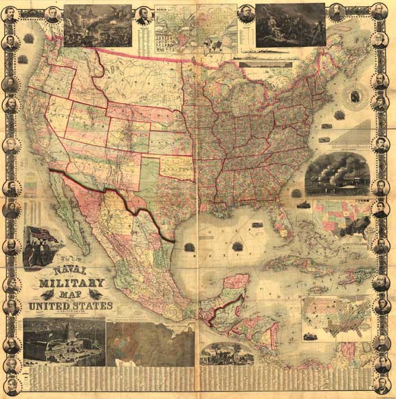
of Congress Archives, 38" h x 28" w. The New Naval and Military
map of the United States; John C.
Smith.; 1862. Created from a print at the Library
of Congress Archives, 68" x 34" A Map of the United States of
America; By John H. Colton;1862.
Created from a print at the Library of Congress
Archives; 31" h x 41" w. Johnson's Map of North
America; from an original copy from
the Illustrated Family Atlas of the World by
Johnson & Ward, 1863; 24" h x 18" w. Washington, D.C.; A.
J. Johnson, Illustrated Family Atlas of the World,
1865. Created from an original copy; 20" h x 27"
w. Clarion County, PA; Pomeroy,
1865. Created from a map at the Library of
Congress; 51" h x 35" w. Arizona & New Mexico;
Mitchell.; 1867. Created from a print at the
Library of Congress Archives, 17" x 22" United States;
Mitchell.; 1867. Created from an original copy,
16" x 24" Los Angeles as it Appeared in
1871; Gores; 1929; from a copy at the
Library of Congress Archives; 17" x 24" Gray's New Map of the United
States; Created from an original copy;
1879; 17" h x 22" w. Massachusetts Railroad and
Township Map; Williams & Co.;
1879. Created from a print at the Library of
Congress Archives; 21" h x 32" w. Palisades of the Potomac;
H.W. Brewer; 1890. Created from a print at the
Library of Congress Archives; 30" x 20" Solano County, California;
1890; from a copy at the Library of Congress
Archives; 42" x 51" Map of California for Cyclers;
1895; George Blum. Created from a print at the
Library of Congress Archives; approx. 19" h x 13"
w State, Country and Geographic
Maps from the 1895 Edition of Rand, McNally
& Co.'s New General Atlas. United States; The
Century Atlas.; 1902. Created from an original
copy, 24" h x 32" w. Note: I have a complete copy of
this atlas and can provide copies of any of its
beautiful maps. Contact
me
for further details. Oklahoma; The Century
Atlas.; 1902. Created from an original copy, 17" x
22". Note: I have a complete copy of
this atlas and can provide copies of any of its
beautiful maps. Contact
me
for further details. Territory of New Mexico;
1903; US Department of the Interior. Created from
an original copy; approx. 19" x 24" Clarion PA Topographical Map;
1907; USGS. Created from an original copy; approx.
21" h x 18" w


![]()


Return to the Main Maps page