MAPS OF SOUTHERN AND NEARBY STATES AND CITIES
(arranged by date of publication)
Also see other southern maps in the Atlases section. There are also state maps in the U.S. Maps section.
Click on the small image to see a larger image of a map,
then use the Back button on your Browser to return to this page.
To purchase a map, just click on the Add to Cart button.
A list of the map on this page, with links to the maps:
| CAR-MAP-306
- Virginia...Capt. John Cook, Smith, 1624 |
CAR-MAP-302
- Southeastern U.S., Sanson, 1657 |
| CAR-MAP- 305
- A Map of Virginia, Ferrar, 1667 |
CAR-MAP-339
- A New Map of...Carolina, Gascoyne, 1682 |
| CAR-MAP-519
- Southeast U.S., Barnwell-Hamerton, 1721 |
CAR-MAP-221 - Survey of Northern Neck of Virginia, Warner, 1747 |
| CAR-MAP-267 - Georgia, etc., Bowen, 1748 | CAR-MAP-522
- SE US, Baldwin, 1755 |
| CAR-MAP-156
- North and South Carolina, Bowen, 1767 |
CAR-MAP-189
- South Carolina & Georgia, Jefferys, 1768 |
| CAR-MAP-466
- Virginia, Henry 1770 |
CAR-MAP-577
- Inhabited parts of VA + MD, PA, NJ & NC, Jeffreys et al |
| CAR-MAP-345 - North Carolina, Collett, 1770 | |
| CAR-MAP-346
- North Carolina, Mouzon, 1775 |
CAR-MAP-281
- MD, NJ, DE, etc., Zatta & Mitchell (French), 1785 |
| CAR-MAP-282
- Carolina, Virginia, Zatta & Mitchell (French), 1785 |
CAR-MAP-309
- Kentucky, Barker, 1793 |
| CAR-MAP-330
- Georgia (Southern U.S.), Barker/Carey, 1795 |
CAR-MAP-124
- North Carolina, Carey, 1814 |
| CAR-MAP-301
- Louisiana, Carey, 1814 |
CAR-MAP-375
- Georgia, Lewis, 1817 |
| CAR-MAP-283
- Mississippi, Melish, 1820 |
CAR-MAP-366
- Florida, Tanner, 1823 |
| CAR-MAP-126
- South Carolina, Tanner, 1833 |
CAR-MAP-535
- Texas, Mitchell, 1835 |
| CAR-MAP-367 - Texas, Tanner, 1837 | |
| CAR-MAP-003
- NC, SC & GA, Bradford, 1837 |
CAR-MAP-052
- North and South Carolina, 1837 |
| CAR-MAP-363
- Georgia & Alabama, Burr, 1839 |
CAR-MAP-340
- Virginia, Crozet, 1848 |
| CAR-MAP-332
- Arkansas, 1854 |
CAR-MAP-151
- Georgia, Colton, 1855 |
| CAR-MAP-172
- South Carolina, Colton, 1855 |
CAR-MAP-419
- North Carolina, Cooke/Colton, 1857 |
| CAR-MAP-420
- Virginia & North Carolina, Mitchell, 1860 |
CAR-MAP-013
- Florida, North & South Carolina, Mitchell, 1860 |
| CAR-MAP-228
- Alabama & Georgia, Mitchell, 1860 |
CAR-MAP-088
- North and South Carolina, Johnson, 1861 |
| CAR-MAP-101
- North and South Carolina, Colton, 1861 |
CAR-MAP-059
- Southern States, Colton, 1861 |
| CAR-MAP-155
- North and South Carolina, Mitchell, 1862 |
CAR-MAP-158
- Virginia & West Virginia, Mitchell, 1863 |
| CAR-MAP-333
- Louisiana, Colton, 1863 |
CAR-MAP-322
- VA, MD & DE, Colton, 1864 |
| CAR-MAP-369
- Texas, Schonberg, 1866 |
CAR-MAP-108
- Florida, Johnson, 1866 |
| CAR-MAP-260
- North Carolina, Lindenkohl, 1865 |
CAR-MAP-209
- Alabama & Georgia, Johnson, 1865 |
| CAR-MAP-167
- MD, DE & NJ, Mitchell, 1867 |
CAR-MAP-168
- Arkansas, Mississipippi & Louisiana, Mitchell, 1870 |
| CAR-MAP-235
- North & South Carolina, Asher & Adams, 1872 |
CAR-MAP-230
- Georgia, Rand McNally Business Atlas, w/index, 1872 |
| CAR-MAP-231
- South Carolina, Rand McNally Business Atlas, 1872 |
CAR-MAP-232 - North Carolina, Rand McNally Business Atlas, w/index, 1872 |
| CAR-MAP-337
- Texas, Colton, 1872 |
CAR-MAP-286
- Georgia & Alabama, Asher & Adams, 1873 |
| CAR-MAP-512
- Georgia, Gray's Atlas, 1874 |
CAR-MAP-513
- South Carolina, Gray's Atlas, 1874 |
| CAR-MAP-287
- NC, SC, GA & FL, Warner & Beers, 1877 |
CAR-MAP-169
- Atlanta, Cram, 1892 |
| CAR-MAP-170
- New Orleans, Cram, 1892 |
CAR-MAP-207
- Mississippi, Century Atlas, 1902 |
| CAR-MAP-161
- Georgia, Century Atlas, 1902 |
CAR-MAP-162
- South Carolina, Century Atlas, 1902 |
| CAR-MAP-248
- Relief map of Southern Appalachians, USGS, 1904 |
|
|
|
|
|
|
|
|
Virgina...Capt. John Cook; John Smith; 1624. Created from a print at the Library of Congress Archives; printed 16" h x 20" w. |
 |
|
|
|
|
|
|
|
|
|
|
Southeastern U.S.; Nicolas Sanson; 1657. Created from a print at the Library of Congress Archives; printed 15" h x 21" w. |
 |
|
|
|
|
|
|
|
|
|
|
A Map of Virgina...; John Ferrar; 1667. Created from a print at the Library of Congress Archives; printed 16" h x 20" w. |
 |
|
|
|
|
|
|
|
|
|
|
A New Map of the Country of Carolina; Joel Gascoyne; 1682. Created from a print at the Library of Congress Archives; printed 19" h x 23" w. |
 |
|
|


|
|
|
|
|
|
|
|
A Map of VA, NC, SC, GA, MD, etc, Robert Baldwin, 1755; Created from a copy at the Library of Congress; 16" w x 19" h. |
 |
|
|
|
|
|
|
|
|
|
|
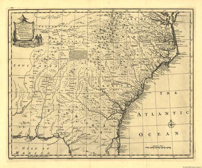
South Carolina and Georgia Coast; from a copy at the Library of Congress Archives; published by Thomas Jefferys; 1768; 23" h x 25" w. |
 |
|
|
|
|
|
|
|
|
|
|
Virginia; from a copy at the Library of Congress Archives; published by John Henry; 1770; 36" h x 48" w. |
 |
|
|
|
|
|
|
|
|
|
|
Virginia et al; from a copy at the Library of Congress Archives; by Joshua Fry and Peter Jefferson, published by Thomas Jeffreys; 1775; 30" h x 47" w. |
 |
|
|
|
|
|
|
|
|
|
|
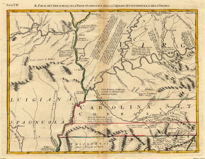
A Compleate Map of North Carolina...; John Collet; 1770. Created from a print at the Library of Congress Archives; printed 28" h x 42" w. |
 |
|
|
|
|
|
|
|
|
|
|
An Accurate Map of North Carolina...; Henry Mouzon; 1775. Created from a print at the Library of Congress Archives; printed 41" h x 56" w. |
 |
|
|
|
|
|
|
|
|
|
|
A reduced size of the above map; printed 22" h x 30" w. |
|
|
|

|
|
|
|
|
|
|
|
Carolina, Virginia, etc.; (French); Antonio Zatta, John Mitchell; 1785. Created from a print at the Library of Congress Archives; 16" h x 21" w. |
 |
|
|
|
|
|
|
|
|
|
|
A Map of Kentucky; Elihu Barker; 1793. Created from a print at the Library of Congress Archives; 17" h x 39" w. |
 |
|
|
|
|
|
|
|
|
|
|
Georgia (southern U.S.); W. Barker/M. Carey; 1795. Created from a print at the Library of Congress Archives; printed 15" x 20" |
 |
|
|
|
|
|
|
|
|
|
|
North Carolina; Mathew Carey; 1814. Created from a print at the Library of Congress Archives; 11" h x 18" w. |
 |
|
|
|
|
|
|
|
|
|
|
Louisiana; Mathew Carey; 1814. Created from a print at the Library of Congress Archives; 15" h x 17" w. |
 |
|
|
|
|
|
|
|
|
|
|
A Map of Georgia; Samuel Lewis, 1817. Created from a print at the Library of Congress Archives; 19" x 16" |
 |
|
|
|
|
|
|
|
|
|
|
Map of Mississippi.; John Melish; 1820. Created from a print at the Library of Congress Archives; 21" h x 16" w. |
 |
|
|
|
|
|
|
|
|
|
|
Tanner's Florida.;Henry Tanner & Charles Blacker Vignoles; 1823. Created from a print at the Library of Congress Archives; 28" h x 24" w. |
 |
|
|

|
|
|
|
|
|
|
|
Texas.;Mitchell; 1835. Created from a print at the Library of Congress Archives; Printed 16" h x 19" w., slightly larger than the original |
 |
|
|
|
|
|
|
|
|
|
|
Texas.;Henry Tanner; 1837. Created from a print at the Library of Congress Archives; 30" h x 36" w. |
 |
|
|


|
|
|
|
|
|
|
|
A map of the internal imporovements of Virginia...; Claudiua Crozet; 1848. Created from a copy at the Library of Congress Archives; 22" x 32" |
 |
|
|
|
|
|
|
|
|
|
|
Colton's Railroad & Township Map of Arkansas...;1854. Created from a copy at the Library of Congress Archives; 22" x 28" |
 |
|
|
|
|
|
|
|
|
|
|
Georgia; published by John H. Colton; 1855. Created from an original copy; 17" h x 22" w (slightly larger than the original). |
 |
|
|
|
|
|
|
|
|
|
|
South Carolina; John H. Colton; 1855; Created from an original copy; 17" h x 22" w (slightly larger than the original). |
 |
|
|
|
|
|
|
|
|
|
|
North Carolina; William D. Cooke, engraved by John H. Colton; 1857; Created from a copy at the Library of Congress; 40" h x 60" w |
 |
|
|
|
|
|
|
|
|
|
|
Virginia & North Carolina; S.A.Mitchell; 1860; Created from a copy at the Library of Congress; 17" h x 22" w |
 |
|
|

|
|
|
|
|
|
|
|
Alabama and Georgia; published by S. A. Mitchell; 1860. Created from an original copy; 17" h x 22" w (slightly larger than the original). |
 |
|
|


|
|
|
|
|
|
|
|
Colton's Map of the Southern States; 1861. Created from a copy at the Library of Congress Archives; 38" x 54" |
 |
|
|
|
|
|
|
|
|
|
|
North & South Carolina; S. A. Mitchell; 1862. Created from an original copy; 17" h x 22" w |
 |
|
|
|
|
|
|
|
|
|
|
Virginia & West Virginia; published by S. A. Mitchell; 1863. Created from an original copy; 17" h x 22" w |
 |
|
|
|
|
|
|
|
|
|
|
J. H. Colton's Map of the state of Louisiana...; 1863. Created from a copy at the Library of Congress Archives; 36" x 43" |
 |
|
|
|
|
|
|
|
|
|
|
Colton's new topographical map of the states of Virginia, Maryland and Delaware...; from a copy at the Library of Congress Archives; 1864; 32" x 45" |
 |
|
|
|
|
|
|
|
|
|
|
A Map of Texas; By Schonberg;1866. Created from a print at the Library of Congress Archives; 19" h x 16" w. |
 |
|
|
|
|
|
|
|
|
|
|
Johnson's Map of Florida; A. J. Johnson; 1866. Created from an original copy; 17" h x 22" w (slightly larger than the original). |
 |
|
|
|
|
|
|
|
|
|
|
North Carolina; A. Lindenkohl; 1865. Created from a copy at the Library of Congress Archives; 16" x 36" |
 |
|
|
|
|
|
|
|
|
|
|
Alabama and Georgia; published by A. J. Johnson; 1865. Created from an original copy; 18" x 26" |
 |
|
|
|
|
|
|
|
|
|
|
Maryland, Delaware and New Jersey; published by S. A. Mitchell; 1867. Created from an original copy; 17" h x 22" w (slightly larger than the original). |
 |
|
|
|
|
|
|
|
|
|
|
Arkansas, Mississippi and Louisiana; published by S. A. Mitchell; 1870. Created from an original copy; 17" h x 22" w (slightly larger than the original). |
 |
|
|
|
|
|
|
|
|
|
|
North and South Carolina, a reproduction of an 1872 map by Asher and Adams. A color version created from an original copy; 19" w x 26" h. |
 |
|
|
|
|
|
|
|
|
|
|
Georgia; Rand McNally Business Atlas, 1872; includes complete index. Created from an original copy; 16" h x 24" w. |
 |
|
|
|
|
|
|
|
|
|
|
South Carolina; Rand McNally Business Atlas, 1872; includes partial index. Created from an original copy; 16" h x 24" w. |
 |
|
|
|
|
|
|
|
|
|
|
North Carolina; Rand McNally Business Atlas, 1872; includes complete index. Created from an original copy; 16" h x 24" w. |
 |
|
|
|
|
|
|
|
|
|
|
Colton's New Map of the State of Texas; 1872. Created from a copy at the Library of Congress Archives; 31" x 37" |
 |
|
|
|
|
|
|
|
|
|
|
Georgia & Alabama; Asher & Adams; 1873. Created from an original copy; 24" h x 16" w (slightly smaller than the original). |
 |
|
|
|
|
|
|
|
|
|
|
Georgia; Gray's Atlas; 1874. Created from an original copy; 17" h x 22" w (slightly larger than the original). |
 |
|
|
|
|
|
|
|
|
|
|
South Carolina; Gray's Atlas; 1874. Created from an original copy; 17" h x 22" w (slightly larger than the original). |
 |
|
|
|
|
|
|
|
|
|
|
County Map of North Carolina, South Carolina, Georgia and Florida; Warner and Beers; 1877. Created from an original copy; 18" h x 15" w. |
 |
|
|
|
|
|
|
|
|
|
|
A Street Map of Atlanta; published by George F. Cram; 1892. Created from an original copy; 17" h x 22" w (larger than the original). |
 |
|
|
|
|
|
|
|
|
|
|
A Street Map of New Orleans; published by George F. Cram; 1892. Created from an original copy; 17" h x 22" w (larger than the original). |
 |
|
|
|
|
|
|
|
|
|
|
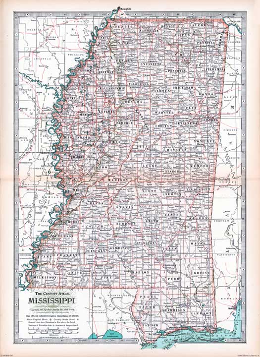
Mississippi; Created from an original copy from The Century Atlas; 1897/1902; 17" h x 22" w (slightly larger than the original). |
 |
|
|
|
|
|
|
|
|
|
|
Georgia; Created from an original copy from The New Century Atlas; 1897/1902; 17" h x 22" w (slightly larger than the original). |
 |
|
|
|
|
|
|
|
|
|
|
South Carolina; Created from an original copy from The New Century Atlas; 1897/1902; 17" h x 22" w (slightly larger than the original). |
 |
|
|
|
|
|
|
|
|
|
|
Relief Map of the Southern Appalachian Region [of the U.S.]; USGS 1904. Created from an original copy; 22" h x 26" w |
 |
|
|
Return to the Main Maps page